Tamarind Falls Access and Hiking Guide
Henrietta · Variable route
A decision guide to a complex waterfall area where legal access, route choice and water level all need current confirmation.
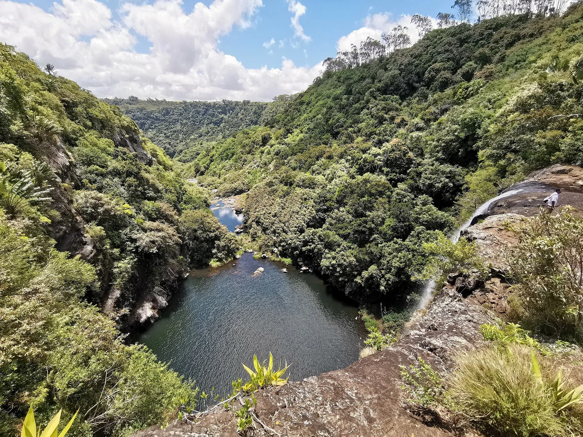
Photo by Z thomas · CC BY-SA 4.0 · Photo credits and edits
An official Forestry Service notice prohibits public access to Le Cabinet, identified as Tamarind Falls. Other outings may use different parcels or permissions, but a map pin or commercial route does not prove self-guided access.
What this walk is like
Tamarind Falls is a gorge landscape in which a modest recorded distance can conceal a demanding outing. The physical experience comes from descending and climbing on uneven terrain, approaching water and making repeated decisions about footing. It should not be assessed like a level three-kilometre walk.
The place name covers different proposed outings rather than one verified public visitor circuit. This page helps you evaluate a plan; it deliberately does not provide independent descent directions. Establish the exact route and permission first. After that, conditions and the group's ability determine what can reasonably be included, not a promised waterfall count.
The scenery can make this look like a relaxed waterfall visit. It is not. Public access is prohibited in the Le Cabinet nature reserve area, while some organised outings may operate through different parcels or permissions. Do not translate a tour listing, social post or map trace into permission for an independent visit.
Understand the terrain.
Is this hike right for you?
A good fit for
- People who have confirmed the exact access arrangement
- Confident hikers accompanied by reliable local expertise
- Waterfall terrain only when recent conditions allow
Think twice if
- Unconfirmed self-guided access
- Heavy rain or a recent torrential rain warning
- Weak knees, limited mobility or unreliable wet-rock footing
Which route this guide covers
An access and planning brief for Tamarind Falls. It is not a verified public route through the Le Cabinet nature reserve.
How the route unfolds
Confirm the outing before the meeting
Establish the route and permission before travelling. The cited organised itinerary meets in Henrietta, but its meeting point is not its trailhead. Ask whether another transfer is needed and retain the exact instructions for your own booking; do not turn that meeting place into a self-guided starting point.
Understand the descent into the gorge
On a permitted outing, expect the change of level to matter more than the map distance. The cited route includes steep, uneven sections where hands may be needed for balance. Keep belongings secured and follow the agreed line instead of looking for a quicker way down to the water.
Let conditions determine the waterfall sections
Near cascades and pools, assess each part with the responsible leader. Wet rock, water movement and the group's ability can change which sections are appropriate. A waterfall count in an itinerary is not a reason to continue when the agreed conditions for the outing are no longer met.
Keep enough energy for the exit
A descent into a gorge also means planning the climb or other agreed exit. Do not spend the whole energy reserve reaching the last waterfall. Keep water, food and time for the return, and confirm the final pickup point before the group separates.
Safety decisions
- Do not enter without permission for the exact route and parcel.
- Do not enter during or soon after heavy rain.
- Never jump into a pool without current local knowledge of depth and submerged hazards.
- A general weather forecast cannot tell you the water level in each stream.
What to carry
- Shoes with wet grip
- At least 1.5 litres of water
- Quick-dry clothing
- Small pack that keeps both hands free
Prepare your hike
Arrange the start, pack for the terrain and leave enough room for the return.
Open your planning sheetGetting there
Confirm the exact parcel, authorised approach and meeting point with the land manager for the proposed outing.
No general public parking or trailhead is verified by this guide.
The Le Cabinet reserve prohibition and permissions for any separate route must be checked individually.
For location and arrival planning, read the Tamarind Falls visitor information before arranging your journey.
Check the planning sourceSource review 22 July 2026. This is separate from a field check.
See the trail areaAccess and timing
Access needs land-manager confirmation
An official Forestry Service notice prohibits public access to Le Cabinet, identified as Tamarind Falls. Other outings may use different parcels or permissions, but a map pin or commercial route does not prove self-guided access.
There is no single official public visitor circuit. An official notice prohibits public access to the Le Cabinet nature reserve area. Confirm the exact parcel and permission with the relevant land manager before any outing. Route choice must also respond to water level, recent rain and the group's ability.
Ask what access is being arranged
Request the named route, the land or parcels involved and who authorises access. A public meeting point is not the same as a permitted trailhead. The Forestry notice concerning Le Cabinet must be addressed for the actual outing; an online booking or a popular track does not answer that question.
Check the plan for wet conditions
Ask how recent rainfall, warnings and water conditions will affect the outing and what would cause cancellation or a route change. Keep a dry alternative in mind. Do not pressure a leader to deliver a fixed sequence of cascades when conditions call for a different decision.
Pack for hands-on movement
Choose shoes with grip on wet ground and secure your belongings in a small backpack. Protect your phone and carry drinking water and food. Leave a change of clothes for afterwards. Keep both hands available for balance; a loose shoulder bag or items carried in the hands complicate steep movement.
Treat swimming as a separate choice
Taking swimwear does not mean you must enter a pool. Discuss whether water entry is part of the actual plan and how it will be assessed on the day. Do not jump, wade across moving water or copy another group's behaviour. Your outing should remain worthwhile if it becomes a dry walk only.
Orient yourself before driving.
This pin shows the reviewed start or trail area precision stated in the guide. It is not turn-by-turn hiking navigation.
Map loads when needed
The weather at your trail.
The coordinate forecast adds rain, gust and ultraviolet context. It never changes the access status above.
Weather methodTamarind Falls
A forecast is not trail status. It cannot confirm access, stream level, rock grip, visibility or whether the route is suitable for your group.
Official warningsQuestions before you go
Does a short distance mean this is an easy walk?
No. Repeated changes of level, uneven footing and wet terrain can dominate the effort. Ask about the proposed route and how much steep movement it involves. Distance alone is a poor way to compare a gorge outing with a reserve track.
Does joining a guided outing resolve the access question?
Only a confirmed permission basis for the exact route resolves it. A guide's local knowledge and legal access are separate matters. Ask who authorises the outing and which land it uses; this reference does not establish a general public right of entry.
Will the outing include swimming and every waterfall?
Neither should be treated as guaranteed. Route choice and water entry depend on permissions, current conditions, the planned activity and the group. Check the actual programme, and accept a changed or cancelled plan when the intended route is unsuitable.
Compare a different kind of outing
Ferney 5 km
Compare a managed land-based walk if you want clearer arrival arrangements and no gorge descent.
Machabée Loop
Compare a forest outing if you want a substantial walk without making water entry part of the plan.
See what was checked, when and by whom.
Official-source review and field verification are kept separate. A recent source check does not mean the route was recently walked.
Source review 7 October 2026
3 cited sources support the published record. Each source has its own review date below.
Field verification not recorded
No approved field record establishes a public route or permission basis.
What changed in this guide
Published evidence reviewed
Source reviewThe cited organised itinerary was rechecked on 7 October 2026. The Forestry Service notice and rain-risk guidance retain their separate review dates. Organised-route figures do not establish public access.
Recorded by Hiking Mauritius editorial desk
Check the evidence yourself
The cited organised itinerary was rechecked on 7 October 2026. The Forestry Service notice and rain-risk guidance retain their separate review dates. Organised-route figures do not establish public access.
Forestry Service. The stated prohibition on public access to Le Cabinet, identified in the notice as Tamarind Falls.
Checked 22 July 2026
Yanature. Typical guided route distance, elevation gain, duration, terrain and equipment advice.
Checked 7 October 2026
Mauritius Meteorological Services. Flash-flood, overflowing watercourse and landslide risk after heavy rain.
Checked 22 July 2026